- Home
- > Nature online
- > Earth
- > Plate tectonics
- > Evidence
Primary navigation
Evidence for plate tectonics
In 1925, scientist and explorer Alfred Wegener published his Theory of Continental Drift, suggesting that all continents were once joined together and have slowly moved apart over time.
He based his theory on similarities between rocks, fossils and glaciers found on different continents. He couldn’t find an explanation, however, for what caused the continents to move.
A few years after publishing his theory, Wegener froze to death on an expedition to Greenland while delivering supplies to a group of stranded men. He died not knowing that his theory was right and would develop into the globally acknowledged theory of plate tectonics.
This slideshow gives an overview of the evidence for plate tectonics
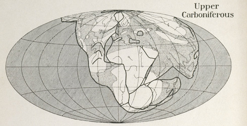
Reconstruction of the map of the world for three periods according to the Displacement Theory. Figs 1-2 from The Origin of Continents and Oceans (1924) by Alfred Wegener.
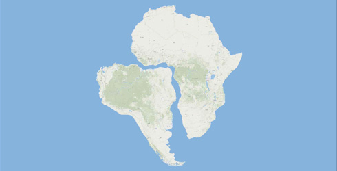
Early evidence
Sixteenth century mapmakers first noticed that the coasts of Africa and South America are shaped as if they were once joined. It wasn't until the 20th century than the explanation for this emerged - the theory of plate tectonics.
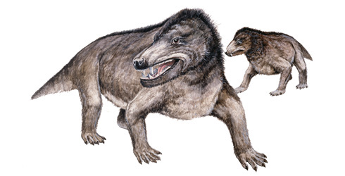
Fossil evidence
Plants, animals and fossils collected around the world showed similarities that were hard to explain unless continents had once been joined.
Cynognathus was a land reptile that that lived 242-240 million years ago. Fossils of this species have been found in both Africa and South America, providing evidence that the two continents were once joined.
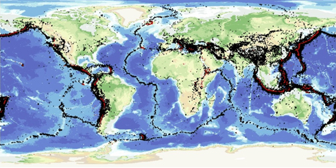
Earthquake evidence
In the 1950s, at the height of the Cold War, above-ground testing of nuclear weapons was banned under international treaty. Each side wanted to know when the other was performing underground nuclear tests, so they started monitoring the movement of the Earth using seismic monitoring stations, looking for signature shockwaves of a nuclear explosion.
What they also found was evidence of earthquakes happening continually, and they found that these quakes occurred along certain lines, near the boundaries between tectonic plates.
The map shows where the majority of the world's earthquakes (black dots) and volcanoes (red dots) occur. Reproduced with the permission of the British Geological Survey © NERC. All rights reserved.
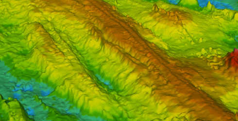
Ocean floor surveys
As they began to survey the oceans, scientists found chains of mountains we now call mid-ocean ridges. Surveys in the 1950s and 1960s provided an even more detailed picture.
Scientists now think submarine mountains are created when tectonic plates move apart and magma from the Earth’s mantle moves up to form new oceanic crust.
On either side of the ridge, the young rock is gradually pushed away in opposite directions and new sea floor formed behind it.
With sea floors able to spread like this, the continents connected to them are also pushed around. This explains how continents can move around over time.
Find out more about mid-ocean ridges at divergent plate boundaries
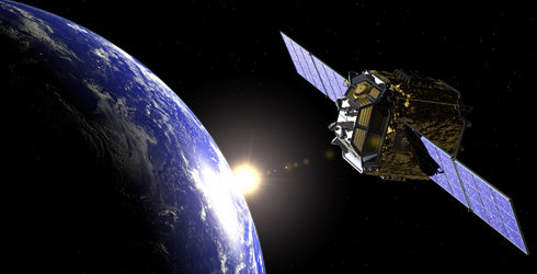
Looking in from space
Global positioning satellites can measure distances to great accuracy. By sending signals to and from measuring stations they can work out how far the continents they are on are moving.
We now know that Europe and North America are moving apart by about 2.3cm every year, about the same speed that your fingernails grow.
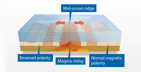
Magnetic memory
Proof of sea floor spreading emerged in 1963, when magnetic readings were taken of the sea floor.
When rocks form, they take on the magnetism of Earth’s polarity, which either faces to the North or South Pole. Earth’s polarity randomly switches every few thousand or hundred thousand years. When it does, it leaves a record in the iron-rich minerals of rocks.
An identical pattern of bands showing switching polarities is found on both sides of a mid-ocean ridge (a series of mountain chains on the ocean floor spreading out from a central valley). This is evidence that the rocks must have formed at the same time and then moved away in opposite directions.
Find out more about mid-ocean ridges at divergent plate boundaries.
Related information
External links
Toolbox

The Museum's smallest members of staff are our flesh-eating beetles, Dermestes maculates, who strip carcasses to the bone.
- Contact and enquiries
- Accessibility
- Site map
- Website terms of use
- © The Trustees of the Natural History Museum, London
- Information about cookies
- Mobile