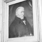
William Smith
William Smith, known as ‘Strata Smith’, was a surveyor who drained marshes and built canals in England in the Industrial Revolution. He made the connection between fossils and the layer of rocks they were in, and used this to create the first geological map of England and Wales. He became known as the 'Father of Stratigraphy' and 'Father of English Geology'.
Smith’s map of 1815, called A Delineation of the Strata of England and Wales with part of Scotland was the first geological map to identify the layers of rock based on the fossils they contained rather than on their composition.
Smith revolutionised the study of geological time and the order of the succession of life. His work inspired nations to map the geology of their countries, laying the founding principles for geological surveys worldwide.
Today, it is accepted that looking at fossils is the most accurate way of comparing sedimentary rocks and answering questions of geological time. In his practical, matter-of-fact way, William Smith had shown the way to read the history of the Earth.
Work
Early years
William Smith was born in Churchill, Oxfordshire, on 23 March 1769 into a family of small farmers. He took an early interest in exploring and collecting fossils. In his teenage years he became skilled at drawing, colouring and carrying out calculations. At 18, he became an assistant to Edward Webb, a Master Surveyor from Stow-on-the-Wold in the Cotswolds. Over the next four years, he got to know the topography, water and mineral resources of Southern England and the Midlands.
Map ideas
Industrial Britain needed a lot of coal and raw material, and the means of transporting them. As a surveyor and prospector, Smith developed a detailed knowledge of different types of rocks. In 1794, he was supervising the construction of the Somerset Coal Canal, to link the River Kennet and the Avon Canal. This gave him an opportunity to travel further around the countryside visiting canal sites.
Smith soon realised the significance of the fact that fossils of a particular kind were always found in the same layers – or strata - of sedimentary rock. He noticed that these always appeared in a definite sequence and that the order of appearance was the same in the rocks in other parts of the country.
By 1796, Smith decided he would publish his knowledge and ideas about rock strata. However, it was only when his work with the Coal Canal Company was terminated in 1799 that he made public his intention to publish a work on the geology of England and Wales.
Long road to map
Smith needed more information for this project, whilst developing and strengthening his own views. He collected and studied natural histories including Robert Plot’s Oxfordshire, John Morton’s Northamptonshire and John Woodward’s Catalogue of English Fossils. These provided him with a way of identifying rock strata by looking at organic fossils embedded in them. Meanwhile he enlarged his coloured sketches in preparation for his geological map. He corresponded with the notable geologists of the day to exchange information.
In 1801, Smith, using his knowledge of geology, succeeded in draining Prisley Bog, a piece of wasteland on the Duke of Bedford’s estate at Woburn, converting it into very valuable agricultural land. This great achievement made him sought after for similar work across the country, adding further to his knowledge of the geology of the country. Travelling thousands of miles each year, he accumulated a mass of information, contributing to the preparation his great geological map.
Unlike many geologists of the time, Smith had to earn his own living, but he also had the patronage of Sir Joseph Banks, the premier scientist of the day and President of the Royal Society. As a landowner, Banks realised the economic significance of Smith’s work and sponsored him. Soirees were held where Smith could seek subscribers and exchange ideas with the scientific intelligentsia of the day.
The map, when eventually published in 1815, was on a scale of five miles to an inch and consisted of 15 sheets. Published by the mapmaker John Cary to Smith’s topographic specifications, it was meticulously hand coloured using 20 tints to represent the different strata, and shading to represent depth. The map was a work of art as well as a scientific innovation.
Approximately 400 copies were issued and many (although not all) bear a number and are signed by William Smith himself. The map was offered in six different forms and cost from five guineas to twelve pounds.
Financial disaster
The Society of Arts awarded Smith with a prize of 50 guineas – the reward had been on offer since 1802 for a first mineralogical map of England and Wales. The project had landed him in great financial difficulties, as the cost of the production was very high.
However, the greatness and originality of Smith’s map was overlooked at first by the scientific community of the time. His humble origins combined with his limited education were an obstacle to acceptance in learned society. He was also the victim of fierce rivalry and unfair discrimination in the newly-founded Geological Society of London. His map did not sell as well as it could have done.
With mounting debts, Smith was forced to sell his prized geological collection. The Treasury purchased the collection of more than 2,500 specimens, 693 species, at a cost of £700, for the British Museum. The collection is now in the Palaeontology Department of the Natural History Museum, with each specimen labelled to show where it was found along with a unique number allocated by Smith.
As a condition of purchase, Smith had to catalogue his collection and in 1817, a portion of this descriptive catalogue was published under the title Stratigraphical System of Organised Fossils. Curious coloured tables were also added - the first of their kind ever published – showing the geological distribution of particular groups. In this he was helped by his nephew John Phillips, later Professor of Geology at Oxford.
Smith continued to travel the country on his professional engagements with his nephew as his assistant. He continued with his publications and produced a series of large-scale county maps that formed his Geological Atlas of England and Wales. He sold all his assets to finance this project. In 1819 he was even obliged to spend time in a debtor’s prison.
Later years
Recognition came slowly for Smith. The Geological Society, who had earlier denied him an honorary fellowship, honoured him as the first recipient of the Wollaston medal in 1831. In 1832, King William IV granted him a pension of £100 per annum for the rest of his life. Some 20 years after the publication of his great map, Smith had the unexpected Honorary Doctorate of Letter (LL.D) bestowed on him by Trinity College, Dublin. Tempting offers came from governments abroad for surveying work and he became a member of the commission which selected the stone for the new Houses of Parliament.
He was active to the end of his life. At the age of seventy, he caught a chill whilst staying in Northampton and died a few days later on 28 August 1839. He was buried there in a large but unmarked grave.
Timeline
| 1758-61 | Captain James Cook's first circumnavigation voyage. |
|---|---|
| 1769 | Born 23 March, Churchill, Oxfordshire, England. |
| 1775-1783 | American War of Independence. |
| 1777 | Father dies. |
| 1787 | First fleet of convicts sails to Australia. |
| 1787 | Becomes assistant to Edward Webb, surveyor. |
| 1794-99 | Employed building the Somerset Coal Canal. |
| 1801 | Drained Prisley Bog, Norfolk. |
| 1802 | Introduced to Sir Joseph Banks. |
| 1805 | Battle of Trafalgar. |
| 1807 | Mother dies. Geological Society of London founded. |
| 1808 | Married around this time. |
| 1815 | Battle of Waterloo. |
| 1815 | Geological map published. |
| 1815-18 | Revisions of the map published. Collections sold to the British Museum. |
| 1816-19 | Strata Identified published. Stratigraphical System published in 1817. |
| 1819 | Smith began publishing geological maps of the counties in England. Imprisoned for debt. Wife enters lunatic asylum around this time. |
| 1820 | A rival geological map, by George Bellas Greenough, was published by the Geological Society. |
| 1820-28 | Travels and works in northern England accompanied by nephew John Phillips. |
| 1831 | New members of the Geological Society award him the Wollaston Medal, presented in 1832. |
| 1832 | Granted government pension of £100 a year. |
| 1835 | Award honorary degree by Trinity College Dublin. |
| 1837 | Victoria ascends the throne. |
| 1837-8 | Member of commission to find building stone for the new Houses of Parliament. |
| 1839 | Dies 28 August, in Northampton, England. |
Geological map
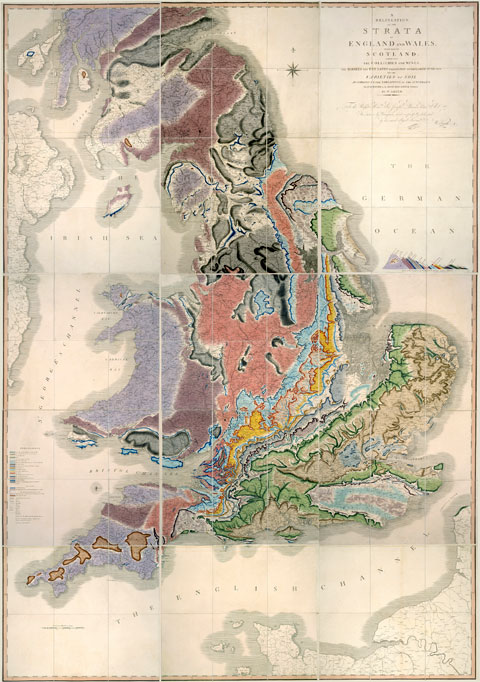
William Smith's map, called Delineation of the Strata of England and Wales with part of Scotland. Published in 1815, it was the first map to show the geology of an entire country.